
Google Maps has transformed our way of interaction over the past few years using different features. For instance, eco-friendly routing lets you take fuel or energy-efficient routes. Whereas, the Live View feature of AI Powered Google Maps allows you to orient yourself when you walk with augmented reality.
Google is going to add several new features that are powered by AI to Maps, such as more immersive navigation, enhanced organized search results, and driving directions, which are simpler to follow. The end result is expected to remind several users of Google search. In this article, you will get to see more updates that become possible to be added due to the power of AI so that you will be able to plan confidently and navigate trips, make sustainable choices, and to get fast inspiration for things to do.
How AI Powered Google Maps Can Help You?
Know Before You Go With Immersive View For Routes:
Google Maps is capable of offering more than 20 billion kilometers of directions per day. The excellent benefits of AI allow people to reimagine how they are able to plan their trips before going. Google announced an Immersive View feature for routes at I/O this year. This new way can help to preview each step of your journey, even when you are walking, driving, and cycling.
This new feature is going to be rolled out in different countries like Amsterdam, Barcelona, Dublin, Florence, Las Vegas, London, Los Angeles, etc. In addition, it is likely to roll out in Miami, New York, Paris, San Francisco, San Jose, Seattle, Tokyo & Venice on both iOS & Android.
Suppose you are willing to bike to the Palace of Fine Arts in San Francisco along the water. You need to request the cycling directions. After that, you have to click the Immersive View preview in order to get a stunning view of your route from start to finish.
You are capable of preparing for every turn as if you were there, with visual turn-by-turn directions. In addition, you can use the time slider in order to plan when you should head out depending on helpful information, such as weather conditions, simulated traffic, etc. Thus, you are capable of avoiding riding during heavy traffic or brainy weather.
Artificial intelligence is used in this case to fuse multiple Street Views & aerial images to inform you of the type of landmark or restaurant before you visit there. In recent times, developers have been capable of generating their immersive experiences by launching Photorealistic 3D Tiles in the Google Maps Platform.
Easily Understand Your Surroundings With Lens In Maps:
With the help of Google Maps, it becomes simpler to understand your surroundings when you get somewhere. For instance, your job will be easier when you try to exit a subway station & orient yourself or when you scope out a new neighborhood & want to find the nearest coffee shop. The Lens in Maps feature, known as Search with Live View, uses augmented reality & AI to acclimate yourself if you go to a new town or want to find local hidden gems.
You need to click on the Lens icon in the search bar. After that, in order to look for information about restaurants, nearby ATMs, coffee shops, and transit stations, you need to lift your phone. This new feature is going to be available in more than fifty new towns like Austin, Las Vegas, Rome, São Paulo & Taipei.
Navigate With Confidence With A More Detailed Map:
Google Maps can provide very helpful information on real-world conditions such as upcoming traffic jams or nearby crashes, and a lot of drivers depend on this. The navigation map is going to reflect the real world more precisely. While you can see updated colors throughout the map, you will also be able to view more realistic buildings so that you can orient yourself in an improved way. For instance, when you drive downtown and want to know the accurate location, it can help you.
A few tricky driving maneuvers happen often on highways, such as an annoying exit that will require you to cross a lot of lanes quickly. Now, you can see improved lane details that will help you to feel ready. The updates will be available in twelve different nations, such as the U.S., Canada, France, Germany, and so on.
You can even see HOV lines soon in the United States along your route to let you decide in more detail how to get to the place you want. The AI-powered speed limit information in Europe is likely to expand to twenty nations to let you stay safe when you can not easily spot speed limit signs on the road. These features will roll out on iOS, Android, etc, as well as for cars with Google Built-in, in the upcoming months.
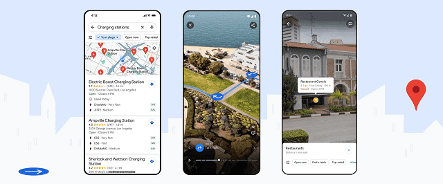
Reduce Charging Anxiety With Even More EV Information:
Are you an electric vehicle driver? Then you must know about the charging anxiety. If you are travelling somewhere or commuting to work, there will be nothing worse than not knowing where to charge in the middle of the journey.
Now, you will get to see more useful charging station information on iOS & Android from think week in cars with Google default EV drivers. For instance, you will get to know if a charger supports their vehicle and how the chargers perform (slow, medium, or fast), which will let you find the charging station that meets your needs the best.
25% of all the available chargers in the United States are down at any given time. So, you can see when any specific charger was used last to avoid wasting time heading to a broken charger. These updates will be rolled out on Android & iOS at any place where EV charging station information will be available.
Developers can also get this information in the Places API on Google Maps Platform. Therefore, companies are able to display this real-time EV charging station information in the apps & their websites.
When you are using Google Maps, a video of the phone screen will show you how to search for EV chargers. From the chargers’ list, you will get to see an option that will specify ‘your charges’ so that you can get to see only the chargers which are compatible with your car. Then, you need to scroll through the option so that you can get to learn more about the charger speeds and when these were last used. Then, you need to tap on an option. Now, you will be taken to that page of the location on Google Maps.
Find Inspiration For Things To Do With New Ways To Search:
It may happen that you know exactly what you are willing to do, but you are not sure where you should go. When you search for something in Google Maps, it will give you even more answers to your questions. In addition, it lets you discover things and find inspiration in innovative ways.
Sometimes, people search for several things, like the best place to look for “animal latte art” or “pumpkin patch with my dog.” In these cases, people will see photo-first results of what they are looking for. These results will be based on the analysis of images that the Google Maps community shares — and everything will be done using advanced image recognition models.
As a user, discovering new spots that you are looking for, with a visual list of places will be possible. You only need to scroll through the results, and then you have to click on an image to know more and go there. It is a very new way to search something in Google Maps, and this feature is rolling out in France, Germany, Japan, the U.K., and the U.S this week. However, this feature will be available in more countries over time.
If you start from scratch and don’t know what to do, such as when you have a free weekend, soon you get to see better-organized search results in order to spark your imagination. Therefore, whether you are in Tokyo, you are able to find “things to do” in order to see thematic place suggestions such as “anime,” “cherry blossoms,” or “art exhibitions.” You have to click on the places you like to learn more, as well as save the options to a list if you wish to check out these later.
The Bottom Line:
In this article, you have seen that Google Maps is transforming the way people can explore & navigate. Artificial intelligence is playing an important role in bringing unique experiences to people around the world.
Frequently Asked Questions
Is Google Maps powered by AI?
Google previewed the feature at I/O 2022. The Immersive feature of Google Maps depends on artificial intelligence. It can fuse street view with aerial view.
What is the new AI feature in Google Maps?
The Immersive view feature uses NeRF, standing for Neural Radiance Fields, in order to generate realistic 3D representations of real-world environments.
How is AI embedded with Google Maps?
Advanced AI technique is used by Google Maps along with computer vision in order to fuse multiple Street Views as well as aerial images to produce the world’s digital model.